Key Volcanoes for Hiking Near Antigua
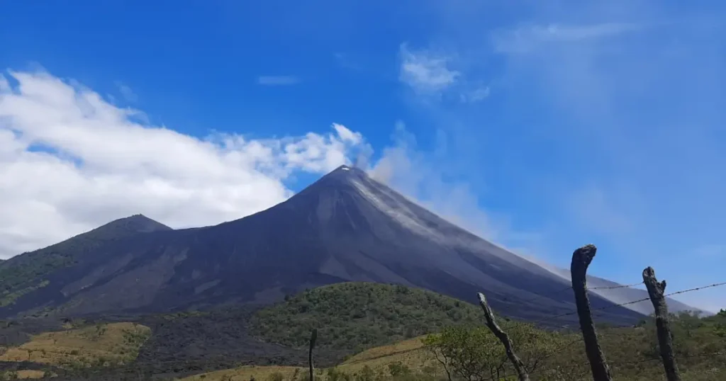
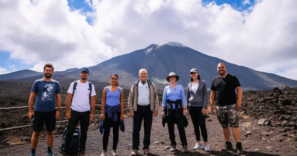
Hiking a volcano near Antigua, Guatemala, primarily means tackling the challenging but rewarding Acatenango Volcano, famous for its incredible, close-up views of the continuously erupting, neighboring Pacaya Volcano, usually done as a 2-day overnight trek with camping to catch sunrise and night eruptions, though strenuous day hikes are also available. The hike involves significant elevation gain through diverse microclimates, loose volcanic scree, and offers rewarding views of Fuego’s lava flows and ash plumes, making it a top adventure for travelers.
Complete Guide to Volcán de Pacaya National Park
There is something profoundly humbling about standing on the flanks of an active volcano, feeling the warmth of the earth beneath your boots while watching steam curl from ancient fissures. Volcán de Pacaya, rising 2,552 meters above sea level in Guatemala’s central highlands, offers precisely this experience—an accessible encounter with one of nature’s most dramatic forces. Unlike its towering neighbors Fuego and Acatenango, Pacaya welcomes hikers of modest fitness levels to walk upon its blackened slopes, where the boundary between solid ground and molten earth feels remarkably thin.
National Geographic has recognized Pacaya as one of the world’s premier climbing destinations for its remarkable accessibility, while Earth Magazine has described its geological structure as a “feast for the senses.” This is not hyperbole. From cloud forests draped in orchids to lunar landscapes of obsidian rock, from panoramic views of Guatemala City to the surreal experience of cooking pizza over thousand-degree lava flows, Pacaya delivers an adventure that defies easy categorization.
Historical and Geological Background
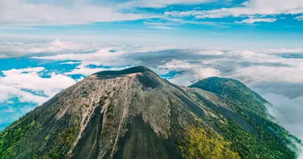
The story of Pacaya begins approximately 23,000 years ago, when volcanic forces first pushed through the earth’s crust in what is now Guatemala’s central region. Today’s volcano represents merely the latest chapter in an ongoing geological narrative—the Pacaya complex encompasses not one but six distinct cones, each bearing witness to different epochs of volcanic activity. The ancient caldera known as Laguna de Calderas, now a tranquil crater lake, once thundered with the same fury that characterizes Pacaya’s modern eruptions. Surrounding peaks including Cerro Chino and Cerro Grande stand as silent monuments to volcanic phases long past.
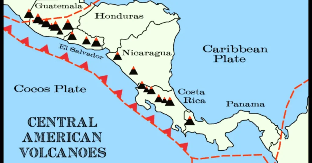
Pacaya holds a significant position within the Central American Volcanic Arc, that great chain of fire stretching from Mexico to Panama where the Cocos Plate subducts beneath the Caribbean Plate. This tectonic drama plays out in real time at Pacaya, which has maintained nearly continuous activity since 1965, making it one of Central America’s most persistently active volcanoes. The Mackenney cone, Pacaya’s primary vent, regularly produces lava flows, pyroclastic emissions, and the characteristic steam plumes that visitors observe from designated safe zones.
The Volcanic Pizza Phenomenon
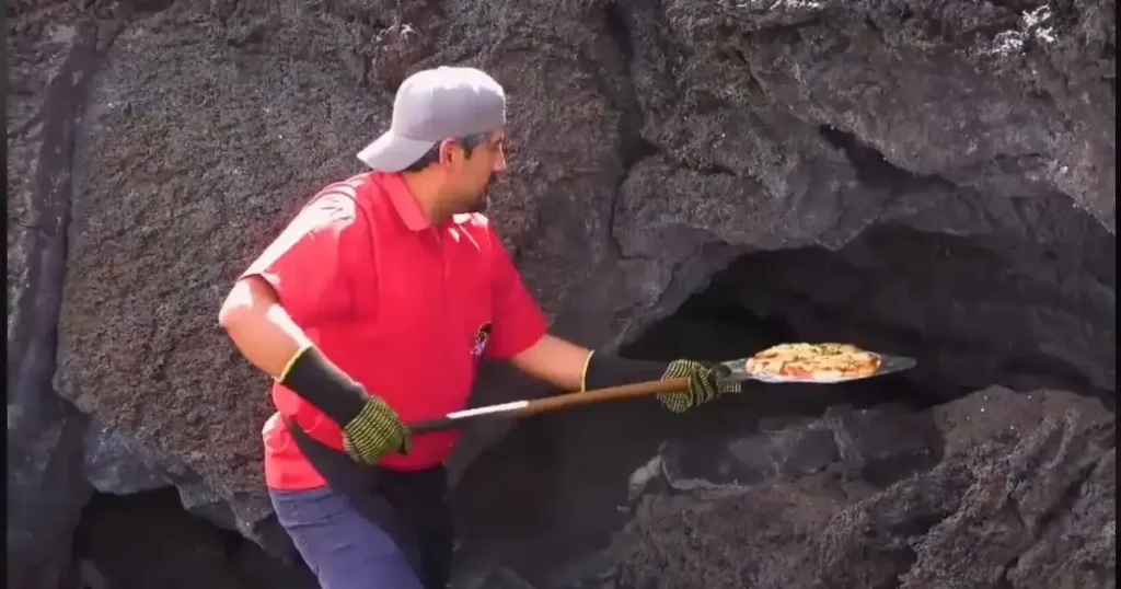
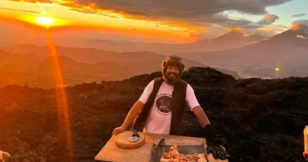
Among Pacaya’s many distinctions, none captures visitor imagination quite like the practice of cooking pizza directly over active lava flows. This seemingly impossible culinary technique has transformed from local curiosity to international attraction, drawing food-focused travelers alongside traditional hikers.
Origins and Development
The volcanic pizza concept originated with David García, a local entrepreneur who recognized that Pacaya’s accessible lava flows presented unprecedented gastronomic possibilities. While the idea faced initial skepticism, persistence and refinement have established volcanic pizza as an essential Pacaya experience—mentioned in travel publications worldwide and featured across social media platforms.
The Cooking Process
The technique relies entirely on geothermal energy. Pizza dough, pre-prepared with toppings, arrives at the cooking site on metal trays (charolas de metal). Guides identify active fissures or accessible lava channels where temperatures exceed 1000 degrees Celsius—heat sufficient to cook a pizza in minutes rather than the quarter-hour required by conventional ovens.
The visual spectacle matches the culinary result. Watching dough bubble and cheese melt mere inches from flowing magma creates an experience that transcends typical adventure tourism. This is not merely eating pizza; it is participating in a primal interaction between human ingenuity and geological force.
Pricing and Logistics (2025)
The volcanic pizza experience commands premium pricing reflective of its uniqueness:
- Small Pizza: Q350 (approximately $46 USD)
- Medium Pizza: Q450 (approximately $59 USD)
- Large Pizza: Q500 (approximately $66 USD)
Arrangements should be made through authorized guides, who coordinate timing with volcanic conditions and trail logistics. Not every visit permits pizza cooking—active flows must be accessible and safety conditions favorable—making successful pizza sessions particularly memorable.
Complete 2025 Pricing and Logistics
Entrance Fees
Volcán de Pacaya National Park maintains a tiered fee structure distinguishing national and international visitors:
| Visitor Category | Fee (Quetzales) | Fee (USD) |
|---|---|---|
| Foreign Tourists | Q100 | $13 |
| National Tourists | Q30 | $4 |
| National Students (with ID) | Q10 | $1.30 |
| Children Under 7 | Free | Free |
Visitors should retain entrance tickets throughout their visit, as verification may occur at multiple checkpoints.
Guide Services
While technically not mandatory, hiring a local guide is strongly recommended and practically essential for safe navigation. Private guide rates accommodate groups of one to ten people:
| Service Type | Fee (Quetzales) | Fee (USD) |
|---|---|---|
| Day Tour (Private Guide) | Q300 | $40 |
| Sunrise/Sunset Tour | Q600 | $80 |
| Camping (Escort Only) | Q495 | $62 |
| Camping (Overnight Guide) | Q1,000 | $128 |
| Horseback Tour | Q300/person | $40/person |
Financial Considerations
Electronic payment infrastructure remains limited throughout the Pacaya region. Visitors should carry sufficient cash in small denominations to cover entrance fees, guide services, food, and any additional purchases. ATM access in San Vicente Pacaya cannot be guaranteed.
Mistakes to Avoid
Inappropriate footwear remains the most common error. Volcanic rock destroys lightweight sneakers and offers no traction on loose tephra. Mountain boots with ankle support are essential—not merely recommended.
Underestimating water needs leads to preventable discomfort. Two liters represents the minimum for a standard day hike. Sunrise, sunset, and camping expeditions require additional supplies.
Attempting unauthorized routes creates genuine danger. The main crater (Mackenney cone) is restricted for documented safety reasons. Guides exist not to limit adventure but to facilitate it safely.
Forgetting sun protection seems obvious but remains frequently neglected. The upper volcano offers no shade. Sunscreen, sunglasses, and a hat prevent uncomfortable consequences.
FAQ Section
How difficult is the Pacaya Volcano hike?
Pacaya rates 4/10 in difficulty, classifying it as moderately easy. Physically active individuals complete the ascent in approximately one hour; those with less conditioning should allow 90 minutes. The trail presents no technical climbing requirements—just steady uphill walking on alternately forested and rocky terrain.
Is Pacaya Volcano safe to visit?
Yes, when proper protocols are followed. The volcano has been continuously active since 1965, but established trails avoid high-risk zones. Mandatory guide accompaniment ensures visitors stay within safe areas. The main crater is strictly off-limits per INSIVUMEH regulations. Ash fall, while occasionally possible, poses minimal risk to properly equipped hikers.
What should I wear and bring to Pacaya?
Essential items include mountain boots with ankle support, long pants, thermal layers, and a windbreaker or rain jacket. Bring at least two liters of water, a flashlight (especially for evening hikes), sunscreen, sunglasses, and a personal first-aid kit containing bandages, ibuprofen, anti-nausea medication, and basic emergency supplies.
Can you really cook pizza on Pacaya Volcano?
Absolutely. Volcanic pizza has become one of Pacaya’s signature experiences. Pizzas cook on metal trays placed directly over lava flows or active fissures, where temperatures exceed 1000°C. Prices range from Q350 to Q500 depending on size. Availability depends on current volcanic conditions and should be arranged through your guide.
How do I get to Pacaya from Guatemala City?
By car: Take CA-9 highway south to kilometer 36.5, turn left toward San Vicente Pacaya, and follow signs to San Francisco de Sales. Total distance is 50km (approximately 2 hours). By public transit: Take Transmetro Line 12 to CENMA, then a bus toward San Vicente Pacaya, and finally a microbus to San Francisco de Sales.
What are the entrance fees for 2025?
Foreign tourists pay Q100 (13USD),nationaltouristsQ30(4 USD), and national students with valid ID Q10 (1.30USD).Childrenunder7enterfree.PrivateguideservicescostQ300(40 USD) for day tours covering groups of 1-10 people.
When is the best time to visit Pacaya Volcano?
Guatemala’s dry season (November through April) offers optimal conditions with clearer skies and better visibility. Within any given day, early morning provides the clearest views before afternoon clouds develop. Sunset tours create dramatic photography opportunities but require comfort with twilight descent.
Guide to Climbing Acatenango Volcano
Few experiences in Central America rival the raw, elemental power of standing atop Volcán Acatenango as its fiery twin, Volcán de Fuego, hurls molten rock into the night sky every twenty minutes. At 3,976 meters above sea level, Guatemala’s third-highest peak offers more than a hiking challenge—it delivers a front-row seat to one of Earth’s most consistently active volcanic spectacles, a journey through four distinct microclimates, and a profound connection to ancient Maya cosmology that viewed these mountains as celestial brothers.
The ascent to Acatenango’s summit is not for the faint of heart. Over five to nine grueling hours, hikers traverse farmland, dense cloud forests, and barren volcanic terrain where temperatures plummet to -5°C and loose volcanic sand turns every step into a battle against gravity. Yet for those who persevere, the reward transcends physical achievement. As documented by cultural resources like Guatemala Food, which chronicles the nation’s culinary and natural heritage, this volcano represents the intersection of adventure tourism and deep-rooted Mesoamerican tradition—a place where the names of gods still echo across the ridgelines.
Whether you’re a seasoned mountaineer seeking your next summit or an adventurous traveler drawn to Guatemala’s volcanic heartland, this guide provides the expert-level detail you need. From mandatory gear lists to the mythology of the “Twin Brothers,” consider this your comprehensive roadmap to one of Central America’s most demanding and rewarding climbs.
Historical and Cultural Background
The Twin Brothers of Maya Cosmology
Long before GPS coordinates and trail markers, the indigenous Maya people of Guatemala’s highlands gazed upon the Fuego-Acatenango volcanic complex and saw something far more profound than geology. According to ancestral legend, these two peaks represent Hunahpú and Ixbalanqué—the Hero Twins of the Popol Vuh, the sacred Maya creation narrative. Volcán de Fuego, perpetually erupting and radiating light, embodies Hunahpú, who became the Sun. Acatenango, silent and watchful, represents Ixbalanqué, transformed into the Moon.
This mythological framework explains why the Maya referred to these volcanoes as “gemelos” or twins, bound together not merely by the ridge known as La Horqueta but by cosmic purpose. The relationship mirrors a theatrical dynamic: Fuego performs its explosive display while Acatenango provides the elevated, stable vantage point from which humanity can safely witness the spectacle. Understanding this cultural context transforms the climb from mere physical exertion into a pilgrimage through living mythology.
Etymology and Naming
The name “Acatenango” itself carries linguistic significance rooted in Nahuatl, the language of the Aztec Empire that influenced Mesoamerican nomenclature through trade and conquest. The word combines three elements: “acalt” (corn cane or reed), “tenam” (wall), and “co” (a locative suffix). Scholars translate this as “Walled Place” or “Wall of Reeds,” likely referencing the agricultural terraces and vegetation that once characterized the volcano’s lower slopes. This agricultural etymology reminds us that these mountains were not merely sacred spaces but practical landscapes where communities cultivated maize—the cornerstone of Mesoamerican civilization.
Understanding Acatenango: Geography and Geology
Physical Structure and Dual Summits
Acatenango is a stratovolcano—a steep, conical peak built from alternating layers of hardened lava, tephra, and volcanic ash accumulated over millennia of eruptive activity. Unlike shield volcanoes with gentle slopes, stratovolcanoes like Acatenango present the dramatic, imposing profiles that define Guatemala’s volcanic chain.
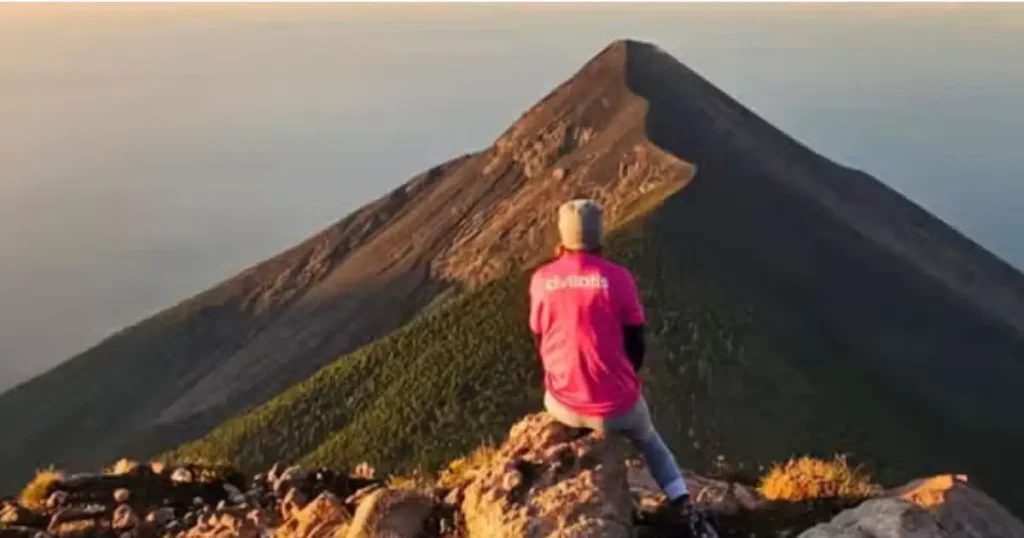
The mountain features two distinct summits. The northern peak, known as Yepocapa or Tercera María, reaches 3,800 meters and offers its own challenging ascent. The southern and principal summit, called El Plato or Bonete, stands at the full 3,976 meters. Interestingly, El Plato does not feature the stereotypical open crater many expect from volcanoes. Instead, hikers find a slightly inclined hollow filled with sandy volcanic soil—a subtle depression rather than a dramatic caldera.
The Fuego-Acatenango Volcanic Complex
Geologically, Acatenango and Fuego function as a single volcanic system rather than independent peaks. Together they form the Fuego-Acatenango massif, comprising five volcanic vents aligned north to south along the Central American Volcanic Arc. This arc stretches approximately 1,500 kilometers along the Pacific coast, the result of the Cocos Plate subducting beneath the Caribbean Plate—a tectonic process that has shaped Guatemala’s landscape and culture for millions of years.
The connecting ridge, La Horqueta, allows adventurous hikers to traverse between the two volcanoes, approaching within 500 meters of Fuego’s active crater. This geological intimacy means that from Acatenango’s slopes, you don’t merely observe Fuego—you feel its eruptions reverberate through the earth beneath your boots.
The Climb: Difficulty Assessment and What to Expect
Overall Difficulty Rating
Every reputable source classifies the Acatenango ascent as difficult. This is not marketing hyperbole—the combination of elevation gain, unstable terrain, extreme temperature variation, and high altitude creates a genuinely challenging mountaineering experience. However, “difficult” does not mean “impossible.” With proper preparation, mental fortitude, and appropriate gear, hikers of reasonable fitness regularly complete the climb.
The difficulty stems from several compounding factors. First, the volcanic sand and gravel that comprise much of the trail absorb energy with every step, similar to running uphill on a beach. Second, the 1,600-meter elevation gain from trailhead to summit places significant cardiovascular demand on the body. Third, the altitude itself—approaching 4,000 meters—reduces oxygen availability and can trigger altitude sickness in susceptible individuals.
Stage-by-Stage Breakdown
Stage 1: Trailhead to Base Camp (5-9 hours)
The journey begins at approximately 2,500 meters elevation near the village of La Soledad. The first two hours are widely considered the most demanding section of the entire climb, featuring steep gradients on loose soil and gravel. Guides typically stop every 500 meters for hydration and rest. As hikers ascend, they pass through agricultural zones, then dense cloud forest characterized by moss-draped trees and perpetual mist, before emerging onto the barren volcanic terrain above the tree line.
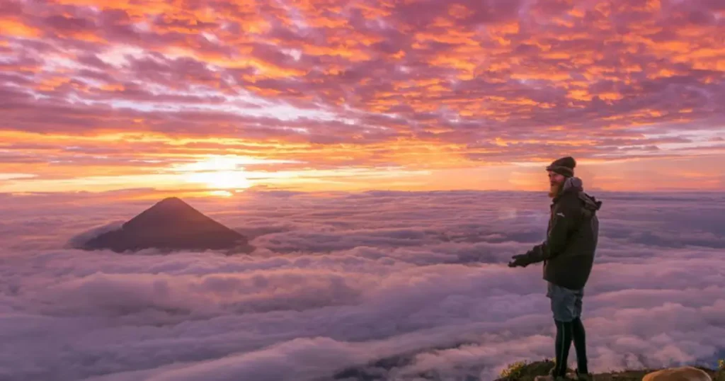
Stage 2: Base Camp Experience
The designated camping area sits above the clouds, offering extraordinary photographic opportunities during sunset. Here, guides construct bonfires where hikers gather for dinner and conversation while watching Fuego erupt against the darkening sky. Sleep comes difficultly—the intense cold can numb extremities even through multiple clothing layers—but the experience of witnessing volcanic eruptions from your tent is unforgettable.
Stage 3: Summit Push (1-1.5 hours)
The final ascent begins around 4:00 AM in complete darkness. Mountaineers consistently describe this section as “super difficult” due to the convergence of factors: physical fatigue from the previous day, temperatures at their coldest point, darkness requiring headlamps, and the notorious loose volcanic sand that provides almost no traction. Each step forward often results in sliding half a step backward. Mental determination becomes as important as physical fitness.
Stage 4: Descent (3 hours)
While faster than the ascent, the descent presents its own challenges. Described by experienced hikers as a “leg burner,” the steep angle places enormous stress on quadriceps and knees. The unstable terrain demands constant attention to foot placement, and accumulated fatigue increases the risk of falls.
Who Should Attempt This Climb?
The ascent is not recommended for older adults, individuals with mobility limitations, or those with cardiovascular conditions. There is no wheelchair access, and the terrain’s instability makes the climb unsuitable for anyone requiring mobility assistance. Children may attempt the climb if they possess exceptional physical stamina, but parents should carefully evaluate their child’s capabilities. Pets are technically permitted but face the same challenges as human hikers.
Attempting the climb as a single-day excursion without camping is strongly discouraged unless you possess expert-level mountaineering experience. The physical toll of ascending and descending 1,600 meters in volcanic sand within a single day leaves most hikers dangerously exhausted.
Essential Gear and Equipment
Clothing System
The key to comfort on Acatenango lies in layering. You will traverse four distinct microclimates—from temperate farmland to frigid alpine conditions—and must be prepared for temperatures ranging from pleasant daytime warmth to -5°C at the summit.
Base Layer: Moisture-wicking synthetic or merino wool underwear and long-sleeve shirt to manage perspiration during the strenuous ascent.
Mid Layer: Insulating fleece or down jacket that traps body heat during rest stops and at camp.
Outer Layer: Waterproof, windproof shell jacket and pants. Weather changes rapidly on the mountain, and rain can arrive without warning.
Extremities: Warm gloves (consider bringing two pairs), a beanie or balaclava, and wool socks are non-negotiable. Many hikers report that their hands go numb despite wearing gloves during the summit push.
Footwear: This single equipment choice can determine your success or failure. Hiking boots with ankle support and aggressive tread are essential. Hikers who attempt the climb in athletic shoes or sneakers consistently report severe blisters, frequent falls, and shoes filling with volcanic sand. Quality hiking boots represent a worthwhile investment for this expedition.
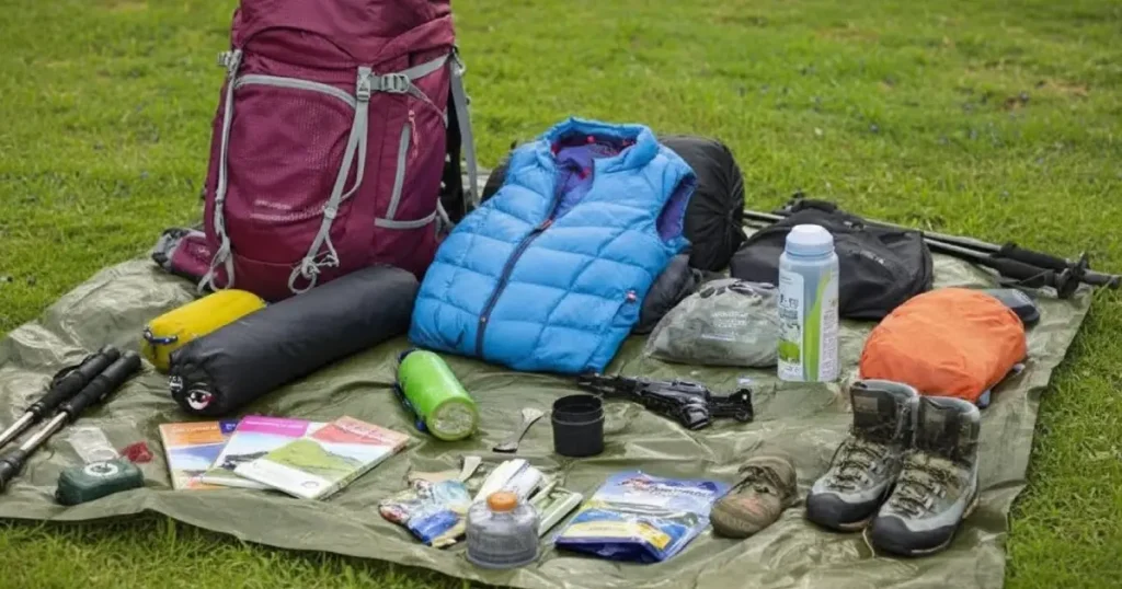
Technical Equipment
Trekking Poles: Highly recommended for both ascent and descent. They reduce strain on knees, provide stability on loose terrain, and help maintain rhythm during the long climb.
Headlamp/Flashlight: Absolutely essential if you plan to attempt the summit push or participate in night hiking. There is no artificial lighting anywhere on the mountain.
Backpack: A 30-40 liter pack with hip belt support to distribute weight comfortably during the multi-hour ascent.
Camping Gear
If joining an organized tour, camping equipment is typically provided. If arranging your own gear, ensure everything is high-quality, waterproof, and rated for freezing temperatures. A four-season tent and sleeping bag rated to at least -10°C provide appropriate protection for summit conditions.
Provisions and Supplies
Food and Water: There are no restaurants, vendors, or water sources on the mountain. You must carry all food and beverages for the entire trip. Pack high-energy, lightweight options: trail mix, energy bars, sandwiches, and at least 2-3 liters of water per person per day.
First Aid Kit: No medical personnel or emergency facilities exist on the volcano. Your kit should include blister treatment, pain relievers, altitude sickness medication (consult your physician), bandages, and any personal medications.
Sun Protection: Sunscreen, lip balm with SPF, sunglasses, and a wide-brimmed hat for daytime hiking above the tree line where UV exposure intensifies.
Insect Repellent: Particularly useful in the cloud forest zones where mosquitoes thrive.
Guide Requirements and Tour Options
Hiring a professional guide is mandatory. Guatemalan regulations prohibit solo ascents of Acatenango, and attempting the climb without authorized guidance is both illegal and extremely inadvisable given the terrain’s difficulty and the absence of marked trails in many sections.
Most visitors book organized tours through operators based in Antigua. These packages typically include transportation from Antigua, guide services, camping equipment, meals, and the entrance fee. Prices vary based on group size and included amenities, but expect to pay between $40-100 USD per person for a standard two-day expedition.
Advance reservation is essential, particularly during peak season (November-April) when demand exceeds capacity.
Fees and Payment
Entry fees must be paid in Guatemalan Quetzales. There are no ATMs, banks, or card payment facilities near the volcano. Withdraw sufficient cash before leaving Antigua to cover fees, tips for guides and porters, and any incidental expenses.
Best Time to Visit
The dry season from November through April offers the highest probability of clear skies and unobstructed views of Fuego’s eruptions. During the wet season (May-October), rain is more frequent, trails become muddy and more treacherous, and cloud cover often obscures the views that make the climb worthwhile. However, wet season ascents are not impossible—they simply require additional preparation and acceptance that weather may compromise visibility.
Porter Services
For those concerned about carrying heavy equipment over the demanding terrain, it is possible to hire porters or even horses to transport gear to the campsite. This service adds cost but can significantly reduce physical strain, allowing you to focus energy on the climb itself.
Expert Tips and Common Mistakes
What Experienced Climbers Know
Pace yourself relentlessly. The most common mistake first-time Acatenango hikers make is starting too fast. The excitement of beginning the adventure leads many to burn through energy reserves in the first hour, leaving them depleted before reaching camp. Follow your guide’s pace, stop when they stop, and resist the urge to race ahead.
Eat breakfast like your summit depends on it—because it does. A substantial, carbohydrate-rich breakfast before leaving Antigua provides the glycogen stores your muscles need for the grueling climb. Skipping breakfast or eating lightly virtually guarantees an energy crash by mid-afternoon.
Hydrate aggressively but strategically. Dehydration compounds altitude effects and accelerates fatigue. However, drinking too much too quickly can cause discomfort during steep sections. Small, frequent sips every 10-15 minutes maintain hydration without overwhelming your stomach.
Prepare for the cold to exceed your expectations. Even hikers who intellectually understand that temperatures will drop to -5°C often underestimate how that cold feels when combined with wind, fatigue, and altitude. Bring more warm clothing than you think you need. No one has ever regretted having an extra fleece layer at 3,976 meters.
The descent demands respect. After summiting, many hikers feel euphoric and rush the descent, leading to falls and knee injuries. The loose volcanic sand that made ascending difficult makes descending treacherous. Take your time, use trekking poles, and protect your knees.
Common Mistakes to Avoid
Wrong footwear: Athletic shoes, fashion sneakers, and casual hiking shoes are inadequate. The consequences include severe blisters, multiple falls, and shoes so filled with volcanic sand they become unwearable.
Insufficient water: Carrying only one liter of water for a 5-9 hour ascent is a recipe for dangerous dehydration.
Attempting a day trip without expert fitness: Unless you are an experienced mountaineer with excellent cardiovascular conditioning, the physical toll of completing the climb without an overnight rest period poses serious risks.
Ignoring altitude symptoms: Headache, nausea, dizziness, and unusual fatigue can signal altitude sickness. Inform your guide immediately if symptoms develop. Descending even a few hundred meters can provide significant relief.
Alcohol consumption: Prohibited during the trek for good reason. Alcohol impairs judgment, accelerates dehydration, and intensifies altitude effects.
The Fuego Experience: Witnessing an Active Volcano
What to Expect
The primary draw for most Acatenango hikers is the opportunity to witness Volcán de Fuego’s eruptions from a safe yet spectacular vantage point. Fuego is among Guatemala’s most consistently active volcanoes, erupting approximately every 15-20 minutes in small, manageable events that last 5-20 seconds each.
During daylight, eruptions appear as billowing ash columns and ejected rock. At night, the spectacle transforms into something almost supernatural—incandescent red lava illuminating the darkness, accompanied by thunderous roars that reverberate across the valley. Even when cloud cover obscures visual observation, you can hear Fuego’s voice and feel tremors through the ground beneath your feet.
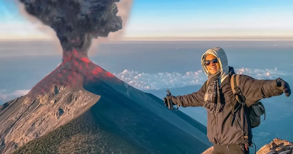
The Optional Fuego Trek
Some tours offer an optional extension: hiking across La Horqueta ridge to a viewpoint approximately 500 meters from Fuego’s main crater. This adds roughly four hours (round trip) to your expedition and is considered difficult due to accumulated fatigue and steep, sandy terrain. Access depends on weather conditions, group fitness, and Fuego’s current activity level—guides will not proceed if volcanic conditions pose elevated risk.
Choose Your Best Option
Climbing Volcán Acatenango represents one of Central America’s premier adventure experiences—a journey that tests physical limits while rewarding perseverance with views that exist nowhere else on Earth. From the first steep steps through cloud forest to the final sandy scramble toward El Plato’s summit, every moment demands something of you. In return, you receive the privilege of watching Volcán de Fuego paint the night sky with liquid fire, of standing above the clouds at sunrise, and of walking through a landscape steeped in Maya mythology.
For those planning Central American travels, Pacaya represents essential Guatemala—a country shaped by volcanic forces both destructive and generative. The same processes that periodically threaten communities have built the fertile highlands that support Guatemalan agriculture and culture. Standing on Pacaya’s slopes, feeling the earth’s warmth rising through hardened lava, visitors glimpse this dynamic relationship directly.